Pages

Tuesday 7 January 2014


Here we have a picture I took a few days ago in the peak district. It's a spire of  siliceous (high silicon dioxide content, in this case from quartz crystals) sand stone known and treasured amongst climbers as millstone grit for its great friction allowing delicate and exciting moves. It formed in the Carboniferous period when earth was sitting far closer to the equator as shown in the below diagram and in deltaic conditions. This means that it is from gradually laid down beds of sediment forming where a river runs out of energy to support what it is carrying and is what is responsible for horizontal (or tilted as seen in the image) weaknesses in the rock. The composition is mainly quartz as this minerals resistance means it lasts long enough to be eroded and deposited many times without breaking down. The quartz minerals in this rock may have come from previous outcrops and may yet form more outcrops for some sort of freaky future life forms to suction their way up!


The spire shown shows clear faulting which can be seen as horizontal breaks cutting through the slanting strata, this tells us that after the formation of this rock it has been tilted and then faulted several times before becoming the base of the famous route Valkryie!

Tuesday 31 December 2013

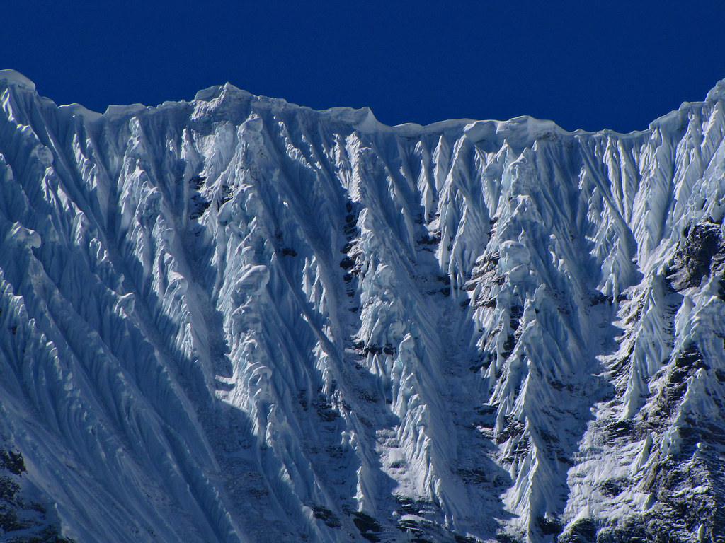
Crazy flutings, found here

So I was going to look at the formation of the Himalayas but that can wait. This picture took my eye. How do those eye catching flutings form? It's certainly not just laid down that way. This article suggests they form in stormy conditions where the wind currents carry granular snow and erode these gulleys but they are probably also partly formed due to some melting of the surface snow followed by channel erosion, this is only possible where the temperature alternates about zero but no for long and these flutings are therefore very typical of mountain ranges in the tropics. They certainly look similar to the cliff in Hawaii shown bellow which would have been a result of both small landslides and fluvial action.


They are surprisingly strong even at steep angle as this draw dropping skiing footage shows (Skip to 1:45 for the good stuff but you know you want to watch the whole thing) probably due to a lack of layers which act as the basis for most avalanche activity.

Who knows what I'll look at next time but check in to check it out!


Sunday 29 December 2013


Hello and welcome to GEOPORN's first post! This blog is here to post one image anywhere from twice a week to once a fortnight that is either completely mind-blowing, stunningly beautiful, interestingly informative or opens your eyes to aspects of our earth you may not be familiar with. Posts will be mostly based around Geology and Geography but may include snippets of Maths, Physics and Chemistry.

Hopefully I will be able to bring you a novel and interesting compendium of such images but it is inevitable that most of these topics can be found to varying degrees of depth elsewhere on the web. What I hope this blog will do differently is good explanations with no unnecessary faff and that it will have a larger impact by focussing around one image.

For the first few posts I will be slowly "zooming" into our earth and will start of by looking at this map of the world. It is a Waterman butterfly projection so named after its creator Steve Waterman in 1996. It excels where other map fail as it is both easy to read and keeps sizes, areas and angles almost equal throughout. Greenland does not dwarf Africa in it's size or become a scrunched up smidge and we see the full extent of the motherland as it sits atop the surprisingly large eastern giants of Kazakhstan and Mongolia. Another advantage is that we see Antarctica in all it's glory without it being peeled out or excluded entirely.

The earliest form of this map came from Bernard Cahill  and was subsequently improved by Gene Keyes. What Waterman did differently was to base it around his waterman polyhedra. A more complex explanation of these can be found under polyhedra here (with the applet being particularly interesting) but essentially they are formed by creating a large sphere around a single sphere in cube closed packing (CCP) and including only the centre points of the spheres who's centres are within the large sphere and then using these as the vertices of the polyhedra. Cube closed packing is one of the tightest arrangement of spheres possible and is present in many crystal structures and is shown in the diagram below found here. The Waterman butterfly projection (main image) is based on mapping imagery projected onto a W5 Waterman Polyhedra but many variations exist, they just don't look quite so good.


Next time we'll zoom in a bit and take a look at the underlying structure of the Himalayas!